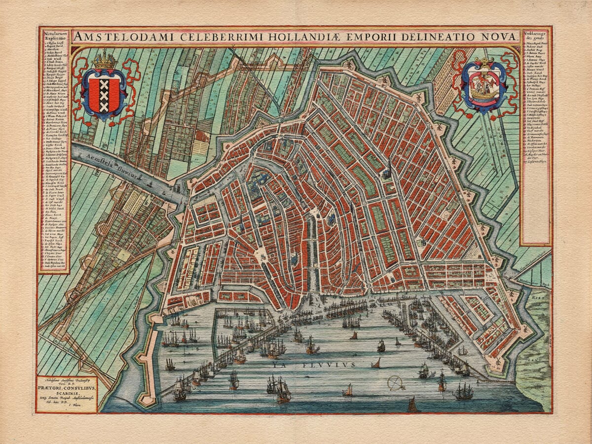
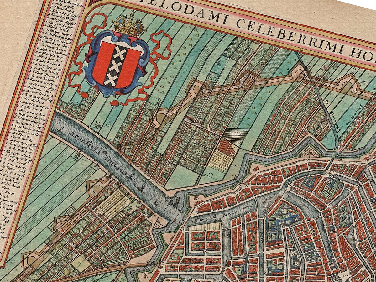
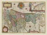
Originally created for the Groot Toonneel der Steden (or Town Atlas of the Low Countries for those of us not fluent in Dutch!) this map shows an unmistakable bird’s eye view of one of Europe’s most famous cities. The map was commissioned in order to commemorate the country’s independence from Spain at the end of he Eighty Years’ War. Here, William Blaue, one of the 17th century’s most highly accredited cartographers, shows the capital of the Netherlands in its Golden Age, during which it was one of the leading trading empires of Europe. The city centre can be seen encased by medieval walls. The recently expanded parameters of Amsterdam and infamous canal systems are clearly depicted. Hundreds of the town’s buildings are encapsulated by the series of canals and the River Amstel, with the stock exchange and fish market right at its centre. Blaue includes a remarkable legend offering no less than 107 numbered locations across the map. The busy hustle and bustle of the city’s port is reflected in the drawing by the inclusion of several sailing ships and Amsterdam’s coat of arms can be seen in the top left corner. Opposite this sits the coat of arms of the Dutch East India Company (Vereenigde Oost-Indische Compagnie).
Authentically aged heavy textured paper • 12 Colour printing technology • Guaranteed to pass or exceed museum quality standards • Bespoke framing service • Free UK Courier Delivery with tracking
Available in three sizes: Large: 24″ x 31″(78.7 x 61cms) Medium: 18″ x 24″(45.5 x 61cms) Small: 19.5″ x 14″ (49.5 x 35.5cms)
A stunning certified FINE ART PRINT on heavy textured art paper — not a poster
Direct from the publisher — no middlemen
Printed in-house in Cornwall
Free UK delivery — international shipping available
Produced to meet — and often exceed — museum-quality standards
Fine Art Map Reproductions – Museum-Quality Printing
Unlike most online offerings, our maps are produced entirely in-house, not outsourced to print-on-demand or drop-shipping services. This allows complete control over quality while offering better value. Each map begins with a high-resolution original, carefully enhanced and printed to order using archival papers and pigment inks for exceptional clarity, depth, and longevity. Every piece is personally overseen — no map leaves our workshop unless it is of a quality we would be proud to display ourselves.
Authentic Old Map Paper & Accurate Colour Reproduction
Paper choice is essential to the authenticity of our maps. We use specially sourced 190gsm paper made in the UK from pure materials and traditionally pressed with natural woollen felts. This process creates a subtle, randomly textured surface that closely resembles an original antique document. Likewise the use of premium quality ink fully saturates the paper, producing remarkable clarity, depth, and historical character. Colour fastness and sharpness will remain good for in excess of 100 years!
Buy Old Maps Online in the UK Today
Trading online since 1999
The Old Map Company of Great Britain offers a vast and carefully curated collection of the very finest expertly reproduced vintage maps. Our range includes works by renowned cartographers such as John Speed and Willem Blaeu, covering Scotland, England, and beyond. Free UK courier delivery is included, with EU, USA, and worldwide shipping available at cost and calculated at checkout. If you need assistance, our team is always happy to help you choose the perfect map.
RECENT REVIEWS
M.F. Leicestershire
Very impressed . . . exceeded my expectations. My son would now like one for Christmas!
Julia Ballester
Very pleased with the quality of the map and it even arrived before it was supposed too.
Nikki
Amazed to find the church where we married on a 400 year old map. Bought as a 1st anniversary gift.
K.H. Middlewhich
I am absolutely delighted with the my antique map. It is so interesting. I would now like to purchase another Map for my sister as a Christmas present.